
Google Maps has many uncommon sights, from weird pentagrams in Kazakhstan to a parked UFO in Romania. Now, a Reddit user has just spotted one of the rarest ones yet: A FLYING STEALTH BOMBER
The B-2 Spirit Bomber can fly at 1,010 km/h (or about 628mph), this image of the bomber was still captured on Google Maps as it was flying across Missouri. This image was found by Redditor Hippowned. The image is slightly blurry and has some red, green, and blue artifacts. It’s because of the way satellites capture images. Google Maps, and Google Earth, gather their images from many sources, but this frame was collected by satellite imagery from Maxar Technologies.
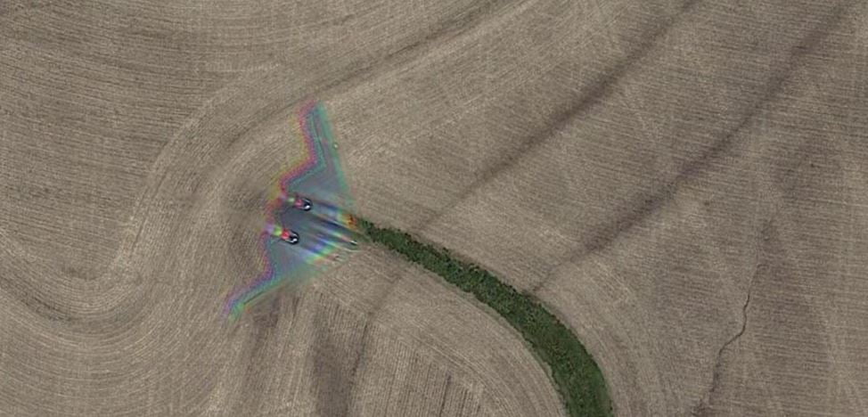
Unlike, Traditional cameras, Satellites don’t focus light onto a sensor, they measure the intensity of wavelengths of light combining them to make a single image. This process is what causes the multicolor banding seen in Google Maps’ shot of the bomber, with the movement of both the satellite and aircraft causing the split between the red, green, and blue parts of the image.
This isn’t the foremost time a stealth bomber has been spotted on Google Maps though, a craft was also seen parked on the runway at Whiteman Air Force Base, the current home of the B-2 Spirit. This is the first time one has been captured in flight.
Google Maps has been going for over 15 years, but much of its imagery is updated every few years, which explains why new, unusual sightings frequently pop up on the service, but it’s unusual to see fast-moving things like planes – and stealth bombers in its patchwork of satellite images.
In 2017, Redditors discovered an aircraft in-flight over the South Downs National Park in the UK, that photo also displays the same red, green and blue artifacts as the B-2 Spirit shot.
Google’s way of compiling satellite shots has proven to be kinda spooky. In 2019, a Google Earth user spotted a shadow of an aircraft under the sea, near the Edinburgh coast in Scotland. A Google spokesperson later told “The Mirror” that “the reason it looks like the plane is underwater is that each satellite image you see on the map is a compilation of several images.”
The spokesperson also said that “fast-moving objects, like planes, often show up in only one of the many images we use for a given area. When this happens, faint remnants of the fast-moving object can sometimes be seen.”